Tapfer
The term Novasolum may also refer to the Kingdom or the Intermicronational Community. See Novasolum (disambiguation).
Origins
The geography of the continent of Novasolum, as it is defined below, was created by the founding members of the Novasolum Regional Community in 2005 and applied to the former Tapfer continent of the Micronational Cartography Society (MCS), with much objection during the conference by Tapfer's founder, Bill Dusch. While the continent is still referred to as "Novasolum" by several micronations that now reside there, the term most prominently refers to the intermicronational community organization than to any particular mapping project. In August 2006, the Novasolum Regional Community members, except for Natopia which left the group, moved to the Geographical Standards Organization world map. The continent's name has since reverted to that of "Tapfer".
General Description
The continent of Novasolum lies in the southern hemishpere of Micras, extending from the temperate latitudes of 30 degrees south into the subarctic region of 70 degrees south, and spanning over 65 degrees of longitude; this is a similar area to that covered by the mainland United States and Canada on Earth.
Novasolum as a whole consists of two main land masses and fourteen significant islands, along with numerous small islands and reefs. The continental shelf is elongated on a roughly southwest-northeast axis, encompassing the large island Mar Sara lying far to the southwest. The shelf is broader to the south of the continent than to the north, where the dropoff lies less than one-third of the distance to the group of islands known as Aerlig.
The general landform of the continent is explained by its volcanic origins. During the distant geological past, the early continental plate looked quite different. As it drifted, it crossed two volcanically active spots. The first of these generated three volcanoes the remnants of which are seen on the peninsular of Lavalonia in the southeast and in the southwesterly Niveusica quadrant of the mainland - these three elevated areas are the oldest terrain on the Continent. The other hotspot had a more profound effect, giving rise to five volcanic mountains in total in a ridge which starts from Crystal Island in the northeast and extends to Mar Sara. Over time, the eruptions and outflows from this spot gave rise to Crystal Island, Novasolum Minor, Mount Talon, Mount Dracon, a chain of undersea peaks to the southwest and, finally, the island Mar Sara. Avonberg, the mountain to the north which dominates the Pendronia region, is the product of a northerly offshoot eruption without which the Talon-Dracon area would be much higher. All of this vulcanism lies in the ancient past; the continent is now completely dormant.
Yellow Island
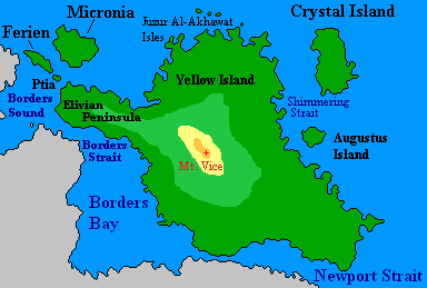
Yellow Island is the large island located northeast of the main continent of Tapfer. It has also been known as Tapfer Minor before the term Yellow Island was standardized by Natopia. Yellow Island is named for the Yellow Territory, a subdivision of Menelmacar which occupied most of the island except for the Elivian Peninsula. The minor outlying islands, Crystal Island, Augustus, Micronia, Ferien,Ptia, and the Juzur Al-Akhawat Isles are often associated with Yellow Island.
Most of Yellow Island is occupied by the Natopian demesne of Flaventia, which takes its name from the Latin word for yellow, flavum. The Natopian capital, Lindstrom is on Yellow Island but is a special Imperial territory. Crystal Island is occupied by Alrodey and Augustus is part of Arboria.
The toponyms of various physical features were standardized in the Tapfer Continental Organization and Standardization Treaty.
Physical features.
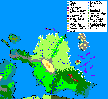
Terrain map.
Resource map.


Mountains
As noted above, the mountains of Novasolum, with only a few small-scale exceptions, are the result of volcanic eruptions, uplifts and lava flows. The three across the south are unrelated to the three in the north of Novasolum Major and the one on Novasolum Minor.
In Lavalonia are Bagel Mountain in the east, a dramatic steep cone rising above the 1500m contour to 3240m at its summit, and Mount Keiran (3109m) which is similarly steep on its southern side but has a connecting ridge falling away to the northeast. This ridge connects to the Eastern Escarpment, a sharp 1500m rise lying back from the eastern Anthelian coast.
Novasolum Minor is almost entirely the cone of Vice Mountain, the central peak which is the highest point of the continent at 5067m. The northwestern peninsular of Novasolum Minor, and the islands of Ferien and Micronia, are part of the original continental plate as is the northern one-third of Novasolum Major.
Above the Eastern Escarpment is the Talon Range, a high east-west ridge the peak of which is Mount Talon (4475m), the highest point on the main landmass. The eruptions and outflows which formed this range also had a secondary outlet away to the north, forming Avonberg (3467m) on top of the pre-existing continental terrain. A large central plateau above 2000m dominates Pendronia (the northern part of Novasolum Major) between the Talon Range and Avonberg, with fairly steep slopes on the western and northern sides of Avonberg to the coast.
As the continental plate drifted further east across the hotspot, the northern outlet closed down and Mount Dracon (4049m) was formed with a large area between it and Mount Talon being filled by lava; as a consequence, the valley between Talon and Dracon is over 2800m high in the middle and a relatively gently sloping plain extends northwest and southeast of that area. South of the Avonberg rise, and west of Mount Dracon, the mountainous area drops away very sharply to a gently sloping coastal plain ranging between 500 and 1000 kilometres wide. As this dropoff continues south, it includes several major gorges where rainfall and the prevailing westerly winds impacted on the different denisties and cooling rates of the volcanic landscape.
The Dracon and Talon uplands feature permanent snow areas and the mountain summits themselves are permanently capped. Alpine terrains, sometimes blanketed in snow, continue south of Mount Dracon and across the southwest quadrant of the continent; snowcaps also feature on the high mountains in the east. However, Avonberg is not permanently capped and receives snow only in the colder half of the year, due to warm air from the north which is more fully discussed below under "Climate".
To the south of the gorge area and Mount Dracon is Niveusica, dominated by a 3000-metre rise topped by a large flat plateau with no well-defined peaks. The highest point of this area is 3066 metres and it was the last creation of the hotspot which also formed the Lavalon Peninsular and its mountains. No clear evidence remains of the actual volcano, arising theories that there were several craters in a confined area and that all are now submerged under an extensive lava cap. Glaciation has also caused significant breakdown of the terrain in Niveusica, which is the oldest terrain on the continent other than small exposed areas of the original continental plate in the north.
As mentioned above, the Vice-Talon-Dracon volcanic rise continues under the sea to the southwest, with a number of submerged peaks ending in the island Mar Sara; this island, although technically part of the continent, does not concern this study.
Letter
This is part of the first Shireroth scavenger hunt. It has nothing to do with Tapfer, and will be deleted when the hunt is over.
You reach the Shireroth National Library, and ask the librarian for all the old books on Tapfer she can find. Eventually she comes back, pushing a wheelbarrow full of Tapfer-themed books. There's no way you're ever going to be able to read all of these! You'll just have to do things the undignified way. You start shaking each one, seeing if any letters fall out. The other patrons of the library watch in bemusement as you go throw the entire Tapfer collection, shaking each book vigorously. A security guard asks you if you need help with something; you say you don't. At last, your patience pays off, and the following letter drops out of one of the older books in the collection:

Rivers
The extent of river systems on the continent is dictated by the mountainous landforms and the climate. All the present-day river systems have developed after the volcanic period, with no clear evidence remaining of previous drainage except in the northwest peninsular of Yellow Island, and the nearby islands. Some of the coastal landforms around the north coast, and in the western gorges, may have been related to ancient rivers.
In Niveusica, permanent glaciation has prevented the formation of significant rivers. Outflow to the sea is by irregular surface flow over frozen terrain and by iceflows and glaciers.
North of this area, snowmelt and rainfall drains from the western side of Mount Dracon and its surrounds. The Rio Montefeltro begins on the southwestern side of the cone of Dracon, descending to the coastal plains to the south of the gorges. West of Dracon are the two branches of the Flussberg SVP, whilst on the northern side of Dracon, two main rivers are featured which are tributaries of the River Altamore. This is the longest river in the north, having its source on the northern side of Mount Talon but flowing west to the sea as the southern frontier of the Pendronia region.
Several short rivers drain the eastern slopes of Avonberg and the northern side of the Talon Range. These all drain more-or-less directly to the sea. A number of other drainage courses are all around the steep northern side of Avonberg and also down the sides of the Eastern Escarpment, without earning status as major rivers. The longest river in the area is the Pendronia River, which drains the southern side of Avonberg and the eastern part of the plateau, to the Gulf of Sol.
The southern side of the Talon Range is the source of the Helion River, which flows initially south, then west and again south to the Egale Lake. Along with tributaries, it drains the snowmelt of the highlands and the light rain across this area. Together with the River Egale in the south, it is the longest river system on the continent. The River Egale itself is a series of broad lakes connected by falls, rapids and multi-threaded streams, and ending in a deep and long tidal estuary facing the southern sea. Another river, long but low in total water volume, drains into this estuary from the northeast.
Novasolum Minor and Lavalonia have many rivers and streams radiating from the mountains to the sea. These mostly form isolated systems without significant tributaries.
Climate
Extending as it does across such a range of latitude, the climates of the continent are varied with only the hot tropics not featured anywhere. The major influences on the climate are the cool, moist westerlies in the 40s and 50s latitudes, polar air from the south, and in the north and northeast warm maritime northerlies and onshore winds.
The large extent of ocean to the north across the subtropical latitudes produces a powerful moderating force for the northeastern part of the main landmass, and all the coastal areas around Borders Bay. Warm moist winds are funneled between Yellow Island and the mainland, across the Bay and onto the Lavalon Peninsular. This entire area is consequently warmer and has more rainfall than it might otherwise have had - winters are mild and summers warm, tending to very warm and humid across the north. Borders Bay itself has only limited exchange of water with the surrounding ocean, and its calm waters are an additional moderating influence on the coastal climates.
The southern part of Lavalonia benefits from the remnant of this warm northerly flow, which meets the polar winds from the south and both moderates the temperatures and increases the rainfall.
The rest of the mainland climate is dictated by the westerlies. These bring consistent rainfall, mostly in winter, west of the mountains and temperatures which range from mild in the middle western coastal plain to cool in Alexandria and cold in the southwest quadrant. Rainfall is also higher in the southwest, falling as snow all year round except at the coastal fringe. The rains brought by the westerlies do not all make it across the mountains; this makes the upland plains south of Talon and east of Dracon the driest part of the continent, although not quite arid. With cold air coming from the south across the Egale basin, and only a light influence from the warmer air towards Borders Bay, this central area of the continent can be quite cold in winter but generally experiences mild summers.
Natural Vegetation
A great variety of vegetation originally covered the continent, with its type and proliferation related strongly to both the climate and to the landforms.
Alpine terrains dominate all the mountain areas, including the heights of Avonberg. These are terrains of hardy grasses and small shrubs, with extensive pine forests native to the northwestern slopes of Mount Dracon. Evergreen subtropical forests are found in northern Gotzborg and most of the lower elevations on Yellow Island. Grasslands and light hardwood trees are extensive across the central part of the mainland and the lower elevations of the Lavalon Peninsular, as well as the central western coastal plains. Some areas of alpine forests are found in the southwestern quadrant where the ground is not frozen.
Historical Notes
Names used on the continent in past versions of the MCS Map:
v4.0.0 - Treesia and Fabon occupied all of the main continent v5.1.2 - the same area is now Menelmacar, but the cities and provinces are the same as before v6.1.0 - same provinces and cities now called Theocracy of Elpidos v6.4.0 - same provinces and cities now appear in the colour of Oira Arnanore Menelmacariva, but the islands with all the Gaelic names are on the other side of the world :\ The "Yellow Territory" of the Imperium of Menelmacar also appears. v6.6.2 - the Yellow Territory has disappeared v6.6.8 - the continent is now vacant
National Borders
Natopia occupies all of Yellow Island, the Ferien and Micronia islands, and the province of Klaasiya on the Lavalon Peninsular.
Alexandria has a colony territory in the west of the continent, south of the Rio Montefeltro, with its eastern and southern border defined by various landforms and minor rivers.
Alexandria occupies an area in the south of the continent, bordered on the west by a river and on the north by the River Egale, the Egale Lake, and the Helion River and its last major tributary.
Matbaa occupies a swathe of land, also in the west of the continent. This is it's colony, Kefr Zeh
Beaugium also holds a segment of Tapfer in the deep south of the continent.