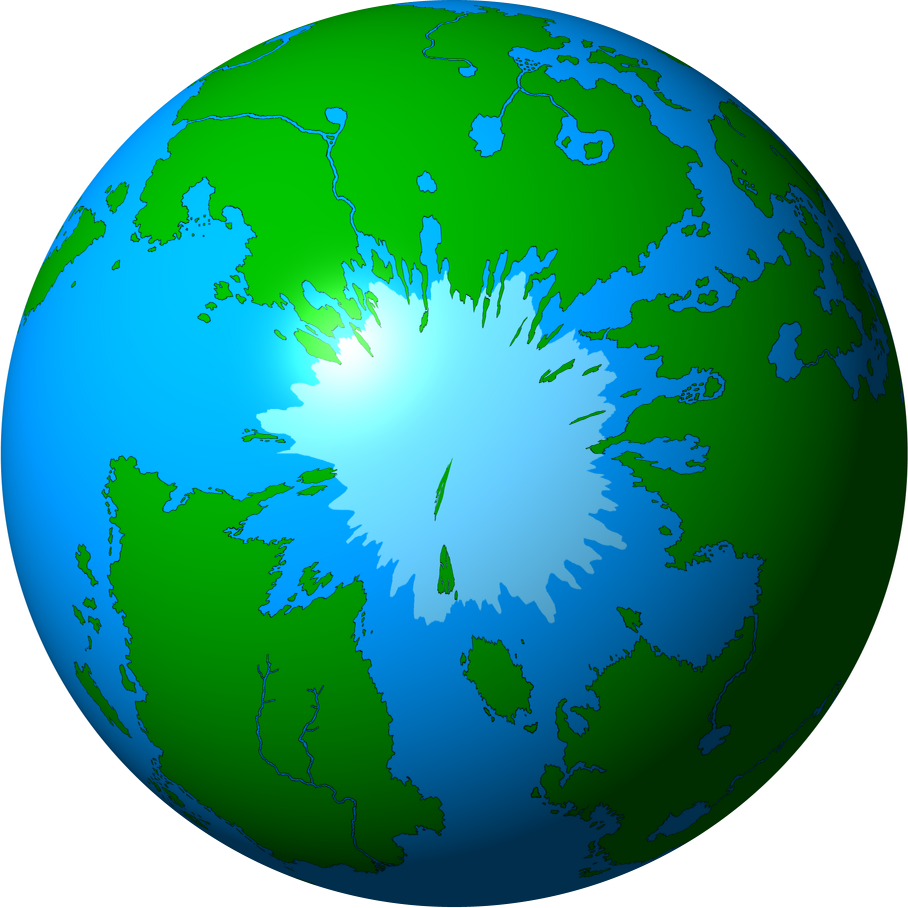
Erik and myself founded the MCS in 2000, and by 2001 the two of us, along with a few other people, had drawn up the full shape of the continents of Micras. We designed it to look realistic, to have just the right amount of land mass of each sort, and so on. And we made an IRONCLAD UNBREAKABLE RULE that no new land could be added, because otherwise every new country would want its own continent and the idea of a consistent geography of Micras would become a mockery.
Then Ryan got control of the MCS. He did a lot of good things and was a decent cartographer, but he also made one extremely stupid move. When some countries wanted more land, instead of telling them to shrivel and die, he gave in and added a whole lot of poorly drawn unbalanced ugly continents and islands into odd corners of the map where they didn't belong.
For the past four years, I (and I think Erik also) have been trying to get rid of these. The MCS has so far refused, both because they don't like change and because there were countries inhabiting these islands that would have to be removed.
Right now, with Jess' generous gift to Shireroth, one of the four offending territories has fallen under Shirerithian control. The island of Leng (the Amokolian territory of Marisco), way in the north, will soon be ours. I think we should celebrate Amokolia's long and glorious history, as well as Jess' generousity, by blowing it up, going one quarter of the way to restoring the MCS Map to its pristine unsullied state.
Let me go on to explain exactly the reasons why the island of Leng is an offense against God and nature:
I: It is too cold for anyone to live there. It's about 500 miles north of Hyperborea. I've always maintained that the northern part of Hyperborea is basically uninhabited because it's too cold to survive there. Even the far south of Hyperborea has a climate similar to Greenland, and its people live in igloos for a good portion of the year. The latitude of Leng on Micras corresponds to the latitude of far northern Greenland on Earth. Except for maybe a few research stations, it's completely uninhabitable. Yet every single country that's claimed land there has given it large cities. During some eras, entire countries have been based on Leng, capital and all. Unless the theme of your country is "domed far-future settlement", any sort of habitation in Leng whatsoever is absurd.
II: The size of Leng on the MCS Map is so misleading as to make it useless. On most map projections, the sizes of objects near the pole are hugely skewed. This is why Greenland usually looks so big on most Earth maps (it's actually only about the size of Mexico). A the length of a degree of longitude near the poles can be determined by multiplying the length of a degree at the equator by the cosine of the latitude. Leng's at around 85 degrees latitude; the cosine of 85 less than .1. That means Leng is in fact a bit smaller than the average island in the Khaz Modan region. Below, I have placed an image of Leng as depicted at 85 degrees north, and Leng as it would appear if it were at the same latitude as Khaz Modan. Leng is not an island, it's a rock.

III: Leng is completely covered by ice. Not in the sense that Greenland is covered by ice. In the sense of "no one could possibly notice it was there without advanced sensing equipment." If we take the ice coverage on the map to be some sort of maximal area of ice in winter, some areas like Hyperborea or Vesteralen in Stormark might be frozen in in the winter. But Leng ought to be constantly and completely covered by the ice sheet. There are islands on Earth covered by the ice sheet that are still being discovered - no one even knew they were there until someone aimed a radar at the ice and found readings consistent with land instead of water.
Leng is an uninhabitable and undetectable tiny rock completely covered by ice. However, its inclusion on the MCS Map encourages countries to claim it as a center of civilization. Stormark had a colony there a long time ago. On the 10 series of maps, the Kingdom of Calundy was a complete Leng-based civilization, complete with capital Marisco City. On the 12 series of maps, it's been a whole province of Amokolia, with two different cities on it (one of which is classified as "large"). The Amokolian city of Danish was located on an outlying "island" all of one-fiftieth of a square mile in area. As long as Leng remains on the map, these sorts of mistakes will continue to be made.
Shireroth has always been one of the strongest supporters of high quality MCS cartography. I ask the Landsraad and Kaiser to petition the MCS to remove Leng from the map completely, under the argument that it is too small to be worth depicting and completely underneath the ice sheet and therefore invisible.
Let us restore the map to its original pristine non-Leng-having state. ONLY THEN WILL THE GODS BE APPEASED!!!!!!!!!





 . Just better not mention New Myzoria then ... but it's more the constitutional stuff I'm worried about than aught else. The constitution most certainly does not allow giving away of lands ad hoc, but it does allow nations to retain control of their lands ... but it doesn't specify if this includes after they die ...
 *looks at Scott's map*