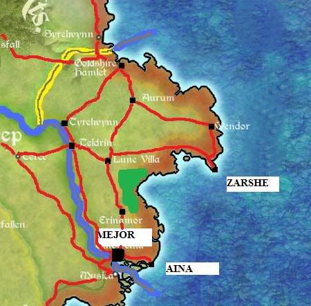
A Map of Khorze

Image
Locked
User avatar
AryezturMejorkhor
Posts: 562
Joined: Thu Jul 23, 2009 4:45 pm

A Map of Khorze

Post by AryezturMejorkhor »

Image

Red = Roads
Dark Blue= River and Sea Boundary
Black Dot = City
Thick Yellow Line = Land Boundary
Green = Forest

As you can see, the roads cross the rivers twice, where the two bridges are, at Mejor and Teldrin.
Aryeztur Mejorkhor

User avatar
Yvain Wintersong
Posts: 352
Joined: Sun Nov 18, 2007 8:17 pm

Re: A Map of Khorze

Post by Yvain Wintersong »

Great Rishi, in accordance with your request on the General Forum I have ordered my cartographers to produce a terrain and infrastructure map of all of Goldshire, and I am happy to say they are now finished.

Image

User avatar
AryezturMejorkhor
Posts: 562
Joined: Thu Jul 23, 2009 4:45 pm

Re: A Map of Khorze

Post by AryezturMejorkhor »

Thank you. However, if possible, can you put the new cities and changed names in? (See my map for reference; I renamed Smotretka Mejor and founded Aina and Zarshe; all three of these cities are now pretty big along with Teldrin; Mejor is the biggest city in the Barony (and Micras) so needs to be made huge; also Lune Villa is a very small village now).
Aryeztur Mejorkhor

User avatar
Malliki Tosha
Posts: 2516
Joined: Wed Aug 26, 2009 10:43 am

Re: A Map of Khorze

Post by Malliki Tosha »

Um, Shirekeep is the largest city of Shireroth. I would have to do a little landscape remodelling on the other side of the Elwynn if you claim that Mejor is the largest.
Malliki Tosha
Owner, Mortis Mercatoria FC
Owner, Newport City FC

User avatar
Malliki Tosha
Posts: 2516
Joined: Wed Aug 26, 2009 10:43 am

Re: A Map of Khorze

Post by Malliki Tosha »

My Lord Duke, what program was used by your cartographers to generate that beautiful map?
Malliki Tosha
Owner, Mortis Mercatoria FC
Owner, Newport City FC

User avatar
Kaiser Leto III
Posts: 540
Joined: Wed Dec 23, 2009 10:58 am

Re: A Map of Khorze

Post by Kaiser Leto III »

Malliki Tosha wrote:My Lord Duke, what program was used by your cartographers to generate that beautiful map?
I assume that he used Photoshop.

I really should learn how to draw those terrains (forests, mountains, etc.).
Signed by the Nifty Hand of,
Leto III Ozymandias 'the Desired' of the Noble Line of Win'Eth

User avatar
Harvey Steffke
Posts: 1599
Joined: Sat Feb 23, 2008 9:28 pm

Re: A Map of Khorze

Post by Harvey Steffke »

AryezturMejorkhor wrote:Mejor is the biggest city in the Barony (and Micras)
I find the statement about being the largest city on Micras a bit dubious. I don't want to get in the way of your development of the barony, but we ARE a newly reorganized territory of what was previously an entirely ignored province. I personally still think of old Airosamente, the birthplace of modern civilization, as the largest city in the world.

Though now that I consider it, this is an interesting concept. I wonder if there is any way to mathematically generate population models of simulated cities based on date of establishment and general prosperity of the country they belong to. This sounds like Spangle territory. I think I'll ask him about it on #micronations tonight.

User avatar
AryezturMejorkhor
Posts: 562
Joined: Thu Jul 23, 2009 4:45 pm

Re: A Map of Khorze

Post by AryezturMejorkhor »

Well perhaps I got a bit too carried away :)
Mejor is the largest city in Khorze and Goldshire though.
Aryeztur Mejorkhor

User avatar
AryezturMejorkhor
Posts: 562
Joined: Thu Jul 23, 2009 4:45 pm

Re: A Map of Khorze

Post by AryezturMejorkhor »

Oh yeah, the map also doesn't show, but there is a road between Teldrin and Mejor now and 2 bridges over the river at those points.
Aryeztur Mejorkhor

User avatar
Ari Rahikkala
Posts: 4326
Joined: Sun Jan 21, 2001 12:56 pm
Contact:

Re: A Map of Khorze

Post by Ari Rahikkala »

Harvey Steffke wrote:
AryezturMejorkhor wrote:Mejor is the biggest city in the Barony (and Micras)
I find the statement about being the largest city on Micras a bit dubious. I don't want to get in the way of your development of the barony, but we ARE a newly reorganized territory of what was previously an entirely ignored province. I personally still think of old Airosamente, the birthplace of modern civilization, as the largest city in the world.

Though now that I consider it, this is an interesting concept. I wonder if there is any way to mathematically generate population models of simulated cities based on date of establishment and general prosperity of the country they belong to. This sounds like Spangle territory. I think I'll ask him about it on #micronations tonight.
Solution: Instead of saying "this place is so big, it's the biggest on the planet", actually tell the population of the city. No need for comparison with anyone else's work, people can just decide for themselves how consistent the figure sounds with the rest of what has been said about Goldshire/Khorze. Also, you won't need to change what you say about your work if someone else comes along with a culture that's about really big and overcrowded cities and submits a larger population figure.
No-one should be without a parasol, Sirocco.

Locked

Return to “Goldshire”

Who is online

Users browsing this forum: No registered users and 6 guests