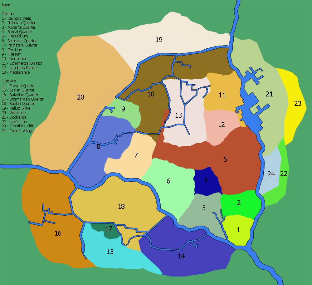
Alright, I will change it. But then I need a new name for 23.
Hmm. Maybe 23 could be the airport? It's not too far off from where it was in the other map; it's located near the Docklands, which might be convenient for freight purposes. I don't know anything about what's in Loki's Line and Caeol's Village, but maybe they could be tourist-friendly sorts of areas if that fitted their intent...
No, no! This is excellent information. I will also add an avenue between the temples (located in the Soloralist Quarter), Ministries (Audente Quarter) and Raynor's Keep.
(That could be aesthetically pleasing too, if you think about it... One avenue from the Landsraad, the other from the temples and Ministries, both converging on the Keep like a V or an arrowhead...)
In order to make a city look really good, I think it's always a good idea to have a concept of what its history and geography were like. I would posit something like this:
-I don't know what the landscape is like, but I sort of imagined the land being sort of the southernmost point in a series of foothills. The land would be rising somewhat toward the Keep with the river cutting through it, so that the shore around the Keep, and possibly on the opposite shores, consists of cliffs, for a good defensive position; but however high the cliffs were at the Keep itself, they'd have to taper down somewhat after a while (for example, Timothy's Cliff being only ten feet high), otherwise it'd cut off effective access to the river (and it would either make the canals impractical, or it would mean that they were set pretty deeply into the ground... though if you wanted to you could do some interesting stuff with that). If I have the chance I might try sketching out a tentative topographic map for reference. Anyway, so much for geography.
-So, city development. Obviously, the Keep came first and would've been the focus of the settlement; considering the distances involved in early Shireroth, the Dukes probably didn't meet often, but when they did come together as a sort of proto-Landsraad, it probably would've been in the Keep itself, and the rest of the government would've been there as well. The original Shirekeep would've been a village, and for the purposes of using the Keep as a safe haven the village would have done well to stick fairly close to its walls (2 through 4, and the southern chunk of 5).
-But if the cliffs near the Keep were too sheer for easy access to the river, development would have shifted fairly quickly to friendlier topography, hence the strong growth of the early city further north, in eastern half of 5 near the river. What would account for the western half of 5 is a bit less clear, but if I'm imagining things right that could have been a relatively low area between two hills. So, you could have a major east-west trade route there, coming from the direction of the Hub (which might eventually have contributed to it becoming the Hub), and that western strip of the Old City could have grown up around it, spreading west from the river.
-With all the development happening on lower ground, the common people would have gravitated away from 2, 3, and 4. But those areas would still have been nearer the defenses of the Keep, above any floods, have commanding views, and would suddenly not be occupied by too many people who would complain about redevelopment... in other words, the kind of place that an increasingly rich young city might convert into government buildings, homes for the well-to-do, and generally higher-class districts. Whether or not they would have acquired their more national characteristics by this particular point is up for debate, but it would lay the foundation for having important stuff in those areas, including the Ministries in what would become the Audente Quarter. I'm visualizing 6 as being roughly part of the same process, but happening later, growing alongside the westward extension of 5. The Soloralist Quarter, therefore, might have a somewhat more planned and orderly look than 2 through 4.
-Somewhere in this time period city walls would also have become important. The regions north of Shirekeep would not yet have been pacified, so you'd have a city, getting bigger and richer, which would be a tempting target for raiders and which would find it increasingly difficult to fall back on the Keep as its only protection. The walls might possibly have been torn down at a later date, but it might be cool even then to have remnants of them as part of the cityscape. I've got an idea that maybe an old gatehouse or
barbican in the wall could have been what later became the Landsraad building...
...
Wow, that's getting long. Well, I'll stop there for the night. But I think I might do some sketches of all this.